
A Common Visual Language: Driving Smarter Project Delivery with Ortho Maps
The High Cost of the Unknown
In the world of large-scale capital projects, the greatest risk isn't the terrain, the weather, or the supply chain — it’s a lack of clarity. When project managers, engineers, and stakeholders operate in silos, looking at outdated site plans, conflicting survey data, or disconnected models, the results are inevitable. Timelines slip. Budgets bloat. Rework multiplies. Risks compound.
In modern Architecture, Engineering, and Construction (AEC), the margin for error has vanished. Yet, multi-million dollar decisions are routinely made based on lagging indicators, fragmented information, and assumptions about what is actually happening on the ground.
Ortho Maps was established to solve this. Drawing on deep, practical experience in development management, we provide a common visual language. We unite every stakeholder — from the site super in the field to the executive in the boardroom — through precision AEC reality capture and geomatics. We don’t just deliver maps; we integrate high-fidelity spatial data directly into the modern AEC workflow to establish a single, indisputable source of truth.
Spatial data isn't a picture. It's a blueprint for action.
Bridging the Gap Between Site and Studio
Modern construction moves at breakneck speed, but the flow of information often lags weeks behind. The gap between the physical reality of the active job site and the digital models discussed in the studio is where critical errors begin and change orders thrive. Our mission is to permanently bridge that gap through four distinct, integrated layers of spatial intelligence.
The Foundation: Establishing Ground Truth
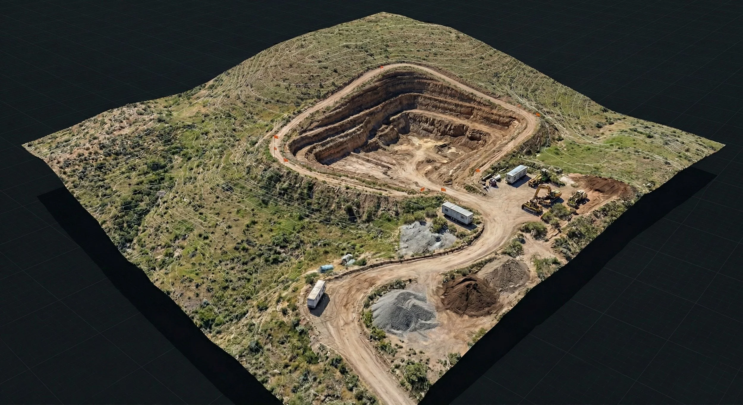
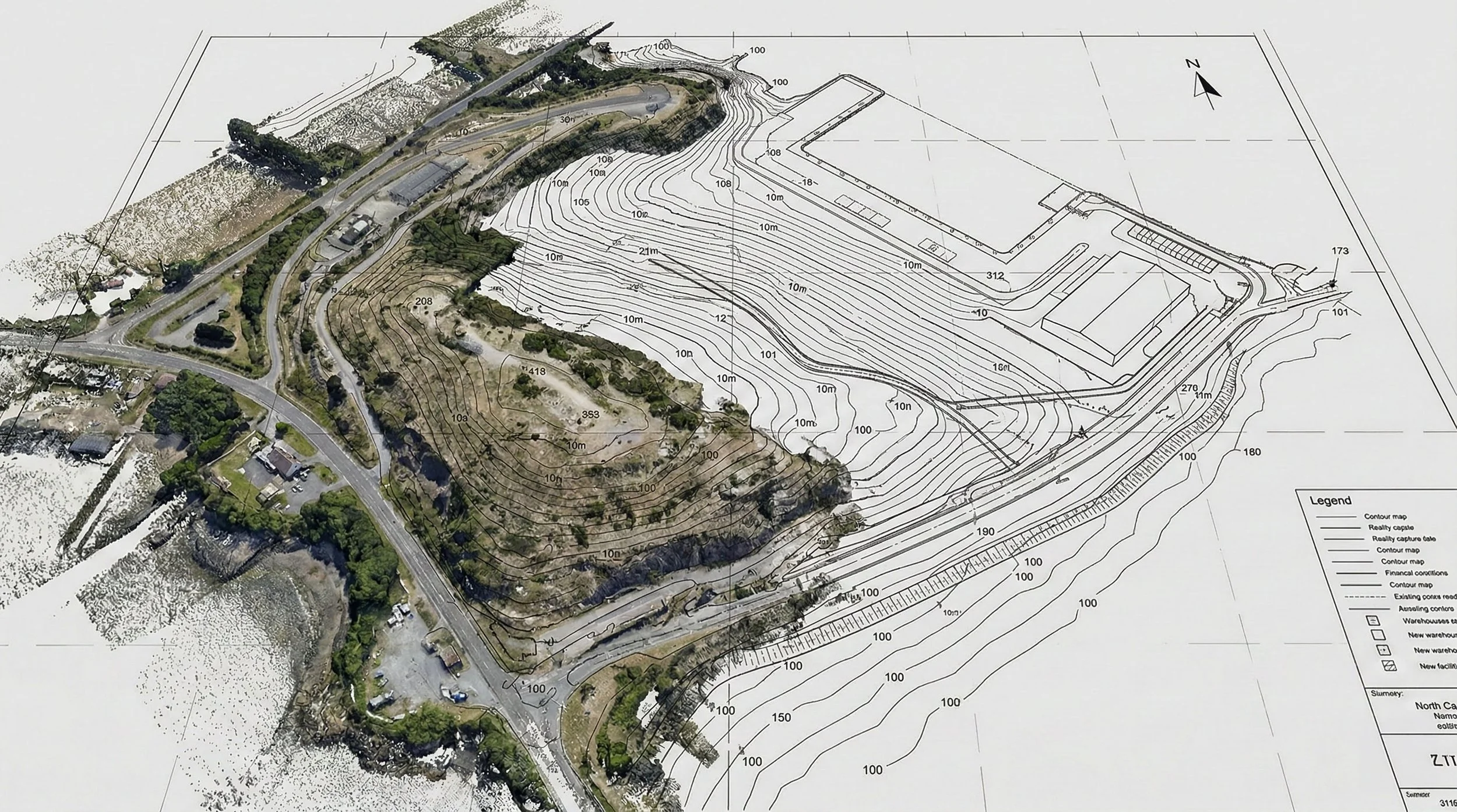
You cannot confidently build what you do not fully understand. Before a single shovel hits the dirt, our Topographic Mapping provides the definitive geometry of the existing site. By generating high-fidelity Digital Surface Models (DSM), bare-earth Digital Terrain Models (DTM), and precise contour lines, we give civil engineers and planners the critical first step required for accurate slope analysis, optimal road alignments, and complex hydraulic design.
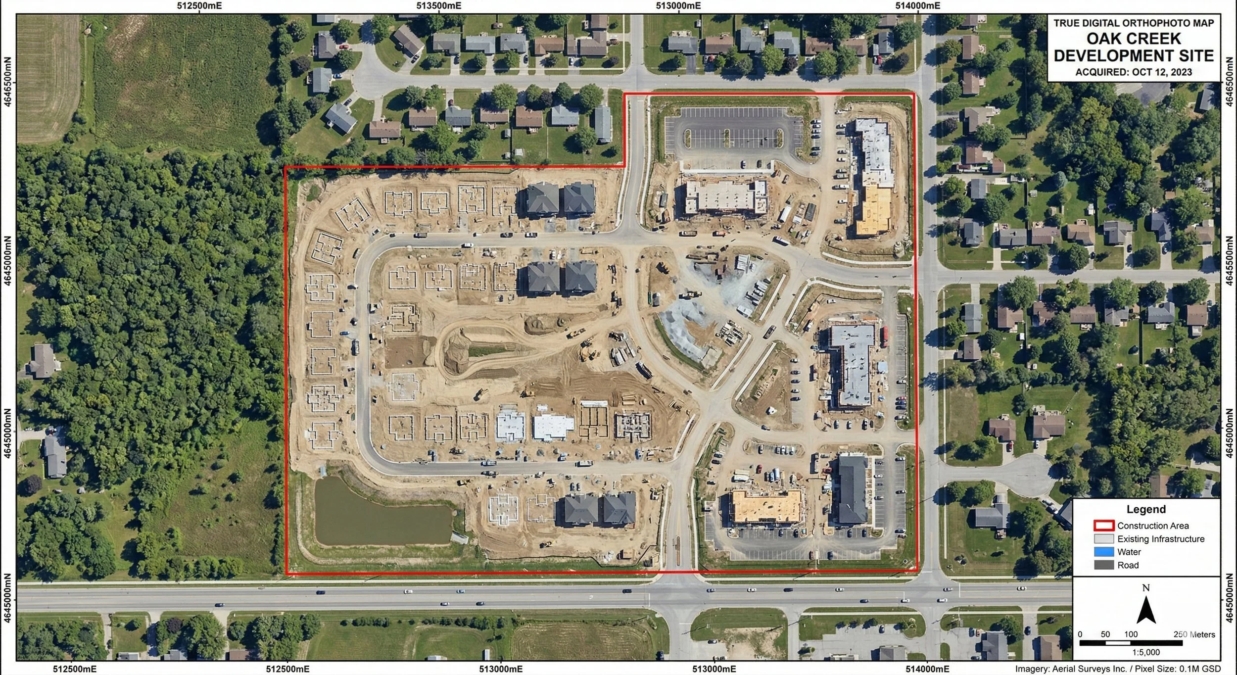
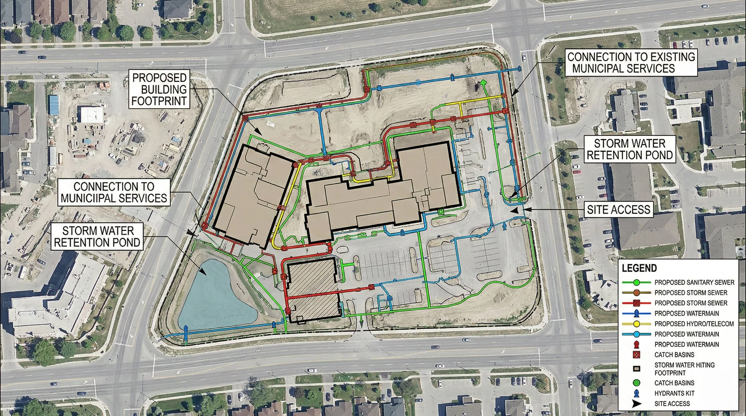
This terrain data is seamlessly layered with our Orthographic Mapping. We move far beyond standard "aerial photography" to generate engineering-grade, geodetically corrected 2D basemaps. By tying millions of data points to rigorous ground control networks, every pixel is geographically true. This creates the authoritative, high-resolution visual baseline required for macro-level site logistics, route planning, and executive progress reporting.
The Economics of Earthmoving
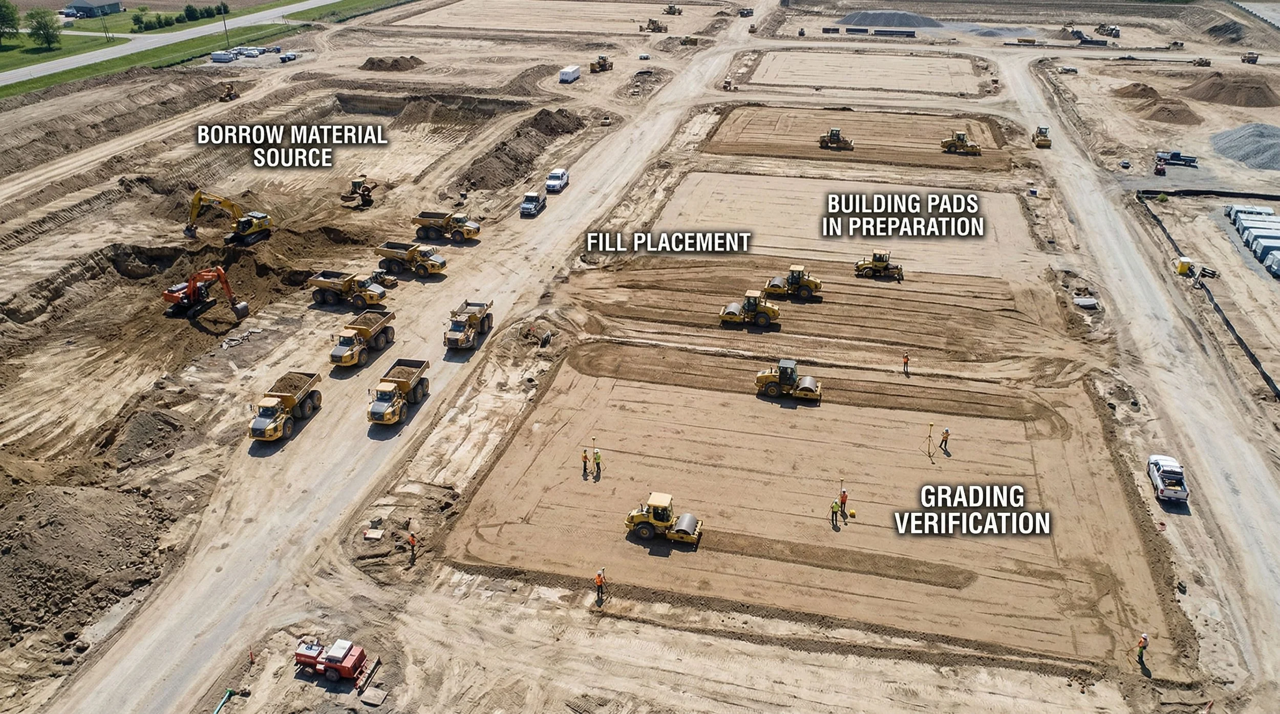
In heavy civil and capital projects, dirt is money, and inaccurate earthworks calculations directly impact the bottom line. Traditional ground-measurement methods are slow and capture only a fraction of the data. Through rapid, high-density drone mapping, our Cut/Fill Quantification & Earthworks Verification transforms how dirt is managed. We provide exceptionally accurate volume calculations for complex stockpiles, borrow pits, trenches, and massive cut/fill grading operations. This intelligence ensures precise material management, prevents costly contractor billing disputes, and keeps heavy civil operations moving at peak efficiency.
Weaving the Digital Thread
As the physical site takes shape, we connect it directly to your CAD and BIM environments. Through Digital Twins & 3D Modeling, we capture the world exactly as it is, transforming physical sites into dimensionally accurate 3D point clouds and textured mesh models. This allows AEC teams to perform remote inspections, spatial planning, and precise measurements from their desktops. It enables BIM/VDC managers to overlay reality capture data directly onto design models (like Revit or Civil 3D) for rapid clash detection, perfectly aligning the physical build with the digital intent.
The Micro and the Macro: Total Site Visibility
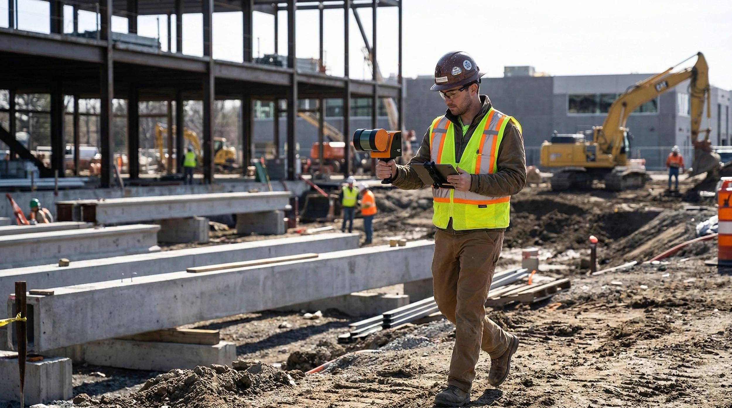
Visibility cannot stop at the exterior envelope. While our aerial sensors capture the macro environment, our terrestrial tools capture the micro. Utilizing Terrestrial SLAM & 360° Walkthroughs, we meticulously digitize the complex interiors of facilities, mechanical rooms, and active construction sites. This creates an immersive, verifiable record of site progress — invaluable for capturing MEP (Mechanical, Electrical, Plumbing) installations before the drywall goes up, ensuring the hidden, as-built reality is perfectly documented.
Simultaneously, we maintain oversight of the larger structural picture through proactive Aerial Inspection & Oversight. Utilizing advanced drone platforms equipped with specialized payloads, we safely access hazardous, elevated, or hard-to-reach areas. This allows clients to rapidly identify structural anomalies, leaks, and general wear-and-tear. It’s a data-driven approach that mitigates operational risk, drastically reduces scaffolding costs, and prevents safety hazards before they impact the schedule.
Making Data Actionable
Raw data, no matter how accurate, is only useful if it can be understood. We synthesize all of these reality capture outputs through advanced GIS & Geospatial Analysis. By mapping spatial data alongside complex environmental constraints, utility right-of-ways, and land-use patterns, we uncover relationships and risks that are invisible to the naked eye. We turn highly complex, multi-layered datasets into clear, presentation-ready intelligence for stakeholders at every level of technical proficiency.
The Calgary Standard
As a Calgary-based firm, we intimately understand the local landscape and the unique operational demands of Southern Alberta’s capital projects. From the sprawling fields of the prairies to the complex terrain of the foothills, we know how local climate, freeze-thaw cycles, and regional regulatory frameworks impact your build.
We are more than a service provider; we are a specialized geomatics partner dedicated to the long-term success of your project and the growth of our shared community.
Ortho Maps. Precision from Every Angle. Data for Every Decision.