
Beyond the Aerial Photo: Understanding Orthographic Mapping in Capital Projects
In the world of Architecture, Engineering, and Construction (AEC), data is currency. The ability to accurately visualize a site, measure progress, and identify risks before they become expensive problems is vital to the success of any capital project.
At Ortho Maps, we often find that while most industry professionals are familiar with drone imagery, fewer fully grasp the technical distinction — and the massive functional gap — between a standard aerial photograph and a true orthographic map.
A pretty picture from above is nice for marketing. But a geometrically corrected orthophoto is an essential design and logistics tool.
Here is a primer on what orthographic maps are and why they are rapidly becoming standard practice for complex development projects.
What Actually is an "Ortho"?
If you take a single photo with a drone looking straight down at a construction site, the center of the image will be relatively accurate. However, due to the camera lens curvature and perspective, objects near the edges of the photo will appear distorted. Tall buildings will seem to "lean" outwards, and straight roads might appear slightly curved at the periphery.
You cannot rely on a standard photo for measurements.
An orthomosaic (or orthophoto) is different. It is created by flying a drone in a precise grid pattern, capturing hundreds or thousands of overlapping images. Advanced photogrammetry software then stitches these images together into one giant, seamless map.
Crucially, the software performs orthorectification. This process removes the effects of perspective distortion and terrain relief. The result is an image that is geometrically accurate everywhere. Every pixel on the map is viewed from a 90-degree, "top-down" perspective.
In short: A standard aerial is just a picture. An orthomosaic is flexible, measurable, actionable data.
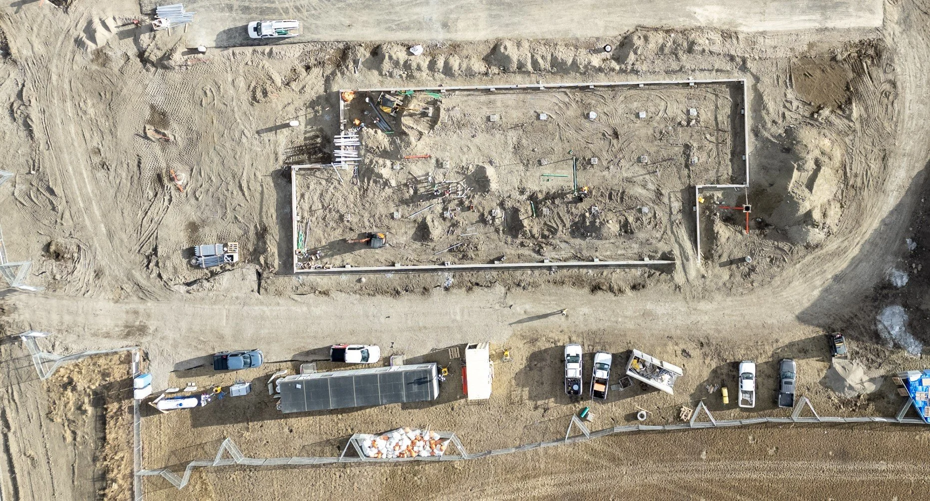
Perspective distortion in a raw aerial photo. Note the “lean” of the buildings, fencing and vehicles.
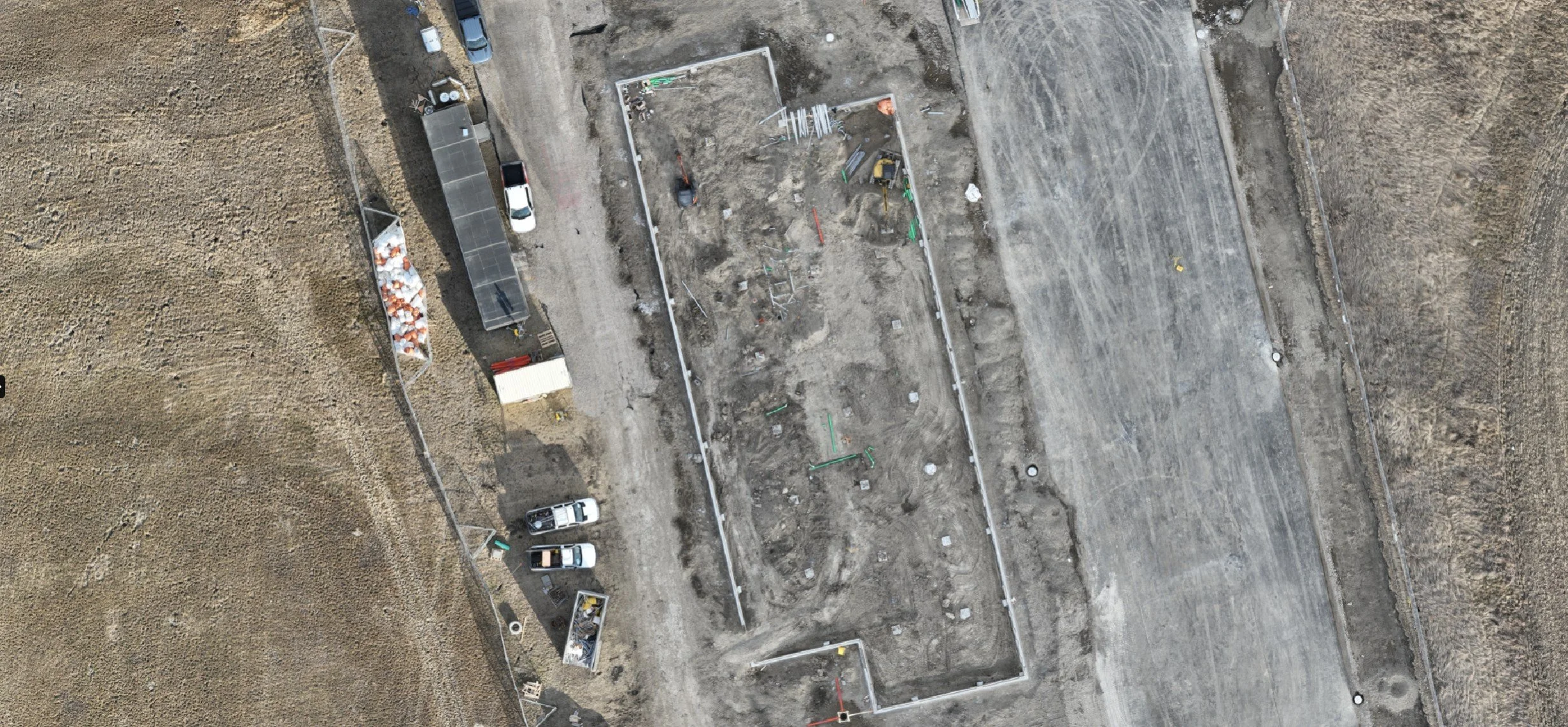
A true orthophoto map. Note the 90-degree “top-down” nature of the perspective.
Applications in AEC and Capital Development
For capital projects involving significant acreage, complex infrastructure, or multiple stakeholders, the ability to generate up-to-date orthomosaics offers immense value across the project lifecycle.
1. Pre-Construction and Site Planning
Before ground is broken, an orthomosaic provides a definitive "current conditions" baseline.
Site Logistics: Planners can accurately measure areas for laydown yards, crane positioning, and temporary access roads directly on the map.
Stakeholder Communication: It is far easier to align stakeholders, city officials, and design teams around a high-resolution, recent map of the actual site than outdated satellite imagery.
See how we assist in early-stage planning with our Orthophoto Mapping Services.
2. Construction Progress and Verification
This is where orthos truly shine. By scheduling regular flights (weekly or monthly), project managers gain an undeniable record of truth.
Schedule Tracking: Compare the current orthomosaic against the BIM model or site plans to visually verify if the foundation work, framing, or paving is on schedule.
Subcontractor Accountability & Validation: There are no arguments about how much dirt was moved or how much concrete was poured when you have measurable photographic evidence dated to the specific week.
High-resolution orthomosaics allow for granular inspection of site progress from the safety of the office.
3. Post-Construction and As-Builts
Once the project is complete, the final orthomosaic serves as crucial documentation for the asset owner.
As-Built Support: The ortho provides a final, accurate record of exterior works, landscaping, utility access points, and pavement conditions at the moment of handover.
Facilities Management: For large campuses or industrial sites, this map becomes the foundational layer for future maintenance planning and asset management software.
The Value of Accurate Data
Incorporating orthographic mapping into capital project development isn't just about using cool technology. It’s about risk mitigation and efficiency.
When you remove guesswork from site measurements and replace assumptions with accurate visual data, project outcomes improve. At Ortho Maps, our focus is on providing that data reliably, accurately, and logically.
If you are looking to integrate measurable aerial data into your next capital project, explore our solutions to see examples of our work, or get in touch to discuss your site parameters.